You have no items in your cart. Want to get some nice things?
Go shopping
“Geography is, to my mind, a subject of high educational value; though not because it affords the means of scientific training. Geography does present its problems, and these of the most interesting, and does afford materials for classification; but it is physical geography only which falls within the definition of a science, and even that is rather a compendium of the results of several sciences than a science itself. But the peculiar value of geography lies in its fitness to nourish the mind with ideas, and to furnish the imagination with pictures. Herein lies the educational value of geography.” (Home Education, p. 271-72)
Geography is a fascinating subject that is embedded in other subjects, like history and science. Children should be familiar with physical geography before beginning formal lessons by going on nature hikes and walking around town. Visiting streams, hills, canyons, and lakes helps them understand bigger landmarks like rivers, oceans, and mountains.
Children will understand maps much better once they have a solid foundation of natural geography and their town’s planning.
CHARLOTTE MASON’S METHODS
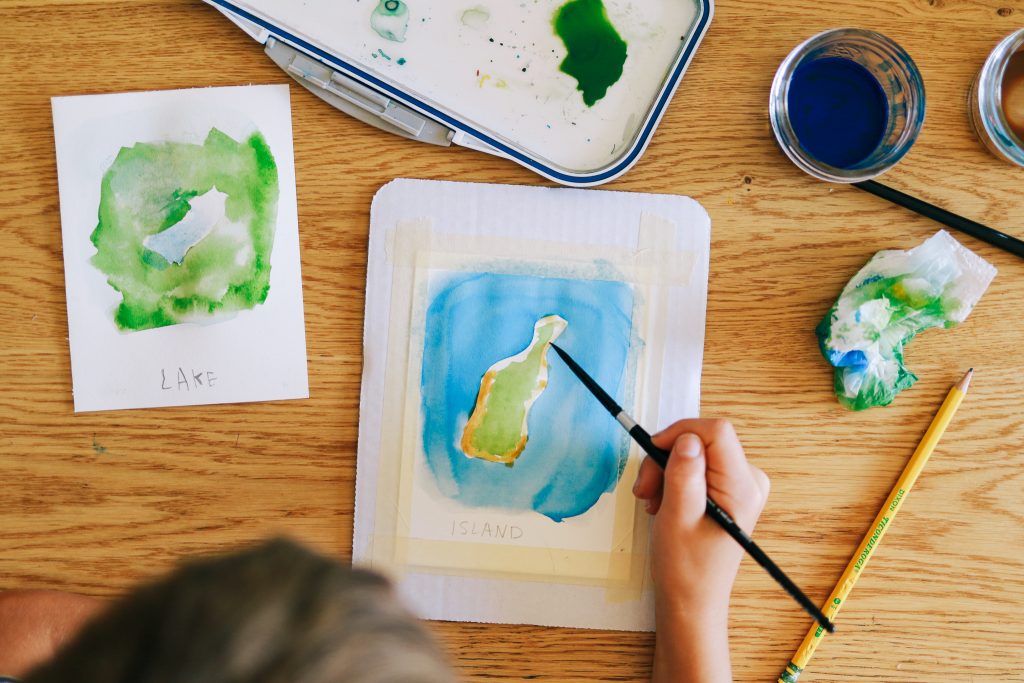
Years 1-3 are dedicated to engaging the child’s heart by introducing them to interesting geographical landmarks and culture around the world, starting with their own country. Children learn how to make maps so they understand how to read them. They start by making maps of their home, neighborhood, and town. They also make geographical landmarks in sand and or clay to better understand topography and the water cycle.
In Charlotte Mason’s schools children in grades 4-6 learn about the geographical regions of their country and how those affected the industry and culture of that region. Now that the child understands how maps are made, they are given map questions before each lesson. Outdoor geography lessons are now given to deepen their understanding of the connection between geography and nature.
Map questions are asked by parent and child answers while looking at map. Alternatively, the child can read questions to himself while looking at a map. Afterwards, the parent asks the children the same questions without looking at the map. After Completing a study of the geographical area/region the child draws a map from memory and then compares it with the real map.
Years 7-12 children focus on world geography, current events, and physical and outdoor geography. They read books about people’s travels and follow those travels on a map, like in grades 4-6. But, from what I’ve read, the focus is mostly on the geography of countries in the news and current events. I’ve been reading Prisoners of Geography for my own education and I plan on assigning it for my high schoolers. The author discusses where history and geography intersect and how that affects culture and politics in major countries today. I just finished reading about Russia and I have a much better understanding of the current war. I think this is an excellent book for high schoolers.

So ,that’s how Charlotte Mason taught geography in her schools, and here’s how I’ve adapted it for my family:
HOW I TEACH GEOGRAPHY
grades 1-3 (form 1)
Years 1-3 are dedicated to engaging the child’s heart and mind by introducing them to interesting geographical landmarks and culture around the world, starting with their own country. Children learn how to make maps so they understand how to read them. They start by making maps of their home, neighborhood, and town. They also make geographical landmarks in sand and or clay to better understand topography and the water cycle.
I use Charlotte Mason’s Elementary Geography and A Child’s Introduction to the World by Heather Alexander. I just alternate between the two so we read about the same topics from both books. These books teach the basics of geography, like land/water forms and latitude and longitude.
I use some activities from Outdoor Geography and Mapmaking with Children about once a month. Only a few activities from Outdoor Geography are developmentally appropriate for this stage. They are usually the first two activities of each section. These activities provide hands-on activities which establish a concrete foundation in geography concepts. This is essential to understand maps in later years.
With my oldest two children we learned about children around the world and introduce world culture. I’ve used the book by DK Children Just Like Me and watched the documentary “Dangerous Ways to School” available on YouTube. It’s like an introduction to, or a sample of, world culture before they dig into individual countries later on.
However, with my third son I’m doing things a little differently. We study geography two days per week, so two lessons per week. One lesson will be from the schedule (see PDF below) and the second lesson will be combined with the older two boys in which we study different countries. As a family we focus on one continent a year (Antarctica and Australia are combined). So that makes a six-year rotation. While studying a continent we dive into individual countries in that continent by reading travel journals, documentaries, and other books. We also do some world culture as well. I’ll elaborate on this in a different post.
A monthly schedule might look like this:
A Child’s Introduction to the World (ACIW)
Elementary Geography (EG)
| Week 1 | Where am I?; In the Beginning (ACIW) |
| Week 2 | How All Things Praise the Lord (EG); Gone Exploring (ACIW) |
| Week 3 | Living on a Sphere| Genesis 1:9-10 |
| Lesson 4 | Sphere/earth object lesson | read “The Librarian Who Measured the Earth (optional) |
grades 4-8 (forms 2 +3)
Map Drills and Map Work
Once children finish Elementary Geography and have made maps of places they know (like their neighborhood, a park, or their town) then they are ready to answer map questions. I usually begin in 2nd or 3rd grade.
In form 2 geography lessons consist of map questions (aka map drills), map work, and world culture.
Thinking up map questions can be a real drain of mental energy, so I occasionally use ChatGPT to generate questions for me, or at least generate the bulk of them, and then I add in a few specific to the atlas we use (DK Compact Atlas 7th edition).
Here are some ideas for map questions:
- Bordering countries
- Large bodies of water and what direction (north, east, south, west)
- Land and water formations, such as: islands, lakes, peninsulas, bays, gulfs, straits, isthmus, capes, fjords)
- Mountain ranges
- Highest peaks
- Elevation (i.e. how many feet above sea level)
- Largest cities
Here is a general prompt to use for ChatGPT
“generate map questions for [country]. Include questions about land and water formations, such as islands, peninsulas, bays, straits, and mountains. Also include questions about bordering countries and large cities. Include answers.“
Make sure you look at the map you’ll be using for lessons to ensure the questions are accurate and answers can be found on the map.
Travelogs + World Culture
Since I’m teaching multiple ages in a family setting I’ve made adjustments to Charlotte’s method. For example, instead of each form studying a different country or continent (see Scope and Sequence below) the whole family studies the same continent for the year. We watch documentaries in addition to reading a book (if I can find a good one on a continent or countries). I haven’t been able to find a good amount of current living geography books, so I add documentaries to fill those gaps. We enjoy Richard Halliburton’s Book of Marvels. For high schoolers and adults, Bill Bryson writes excellent and humorous travelogs. Prisoners of Geography is an excellent book on how physical geography has affected a country’s (and world!) politics. We focus on one continent each year (I combine Australia, Antarctica, and the Arctic).
I’m not sure if documentaries would be considered “Charlotte Mason approved” but when you look at the principles, “to nourish the mind with ideas and furnish the imagination with pictures” I feel that documentaries do just that. In fact, I think they do it better than books because a child is actually seeing what that place looks like instead of imagining something completely different. I wholeheartedly believe in children using their imagination to see imaginary worlds in fiction, but when it comes to geography I think it’s important to see exactly what other countries look like.
Map work and drills and watching a documentary are the “floor” of our geography lessons. If I only have time for a few minutes of geography in the morning then we do map drills and watch a documentary during the afternoon or on the weekend as a family. I try to get a read-aloud book, either fiction or a travelog, that fills my child’s heart and mind with rich ideas related to the geography of that country. Some bonus material that we add is world culture, in the form of picture books, folksongs, architecture, and cuisine. We may read a picture book during lesson time, but everything else is an afternoon or weekend activity.
grades 9-12
I plan on my high school students listening to the daily news and looking up places mentioned on a map. I will require them to read Prisoners of Geography as well as watching documentaries with the family, and possibly reading travelogues, such as ones written by Bill Bryson.
resources
Printable Maps
https://online.seterra.com/en/pdf/4167
https://d-maps.com/pays.php?num_pay=272&lang=en
https://www.geoguessr.com/l/pdf
World Culture
https://folkways.si.edu/lesson-plans (wonderful folksong lesson plans!)
My curriculum guides have a lot of book recommendations for free-reading based on age.
Favorite Documentaries
Dangerous Ways to School on YouTube
Human Planet by BBC (WARNING: cultural nudity in some episodes)
Frozen Planet by BBC
Europe From Above by National Geographic
India From Above by National Geographic
Ancient China From Above by National Geographic
Earth’s Great Rivers by BBC
North America by Discovery Channel
And that is how I currently teach geography in my homeschool!
How do you teach geography and world culture? Do you have any tips or advice I didn’t mention here?